Shakotan 積丹町
しゃこたんちょう
Shakotan covers the tip of the Shakotan Peninsula, which juts into the Sea of Japan west of Otaru. The town is known for the vivid "Shakotan Blue" water around Cape Kamui, for fresh sea urchin in summer, and as the "home of Soran-bushi", the herring fishermen's work song.123 Barely 1,600 people live here, yet the town draws about a million visitors a year, most of them day-trippers in summer.45
- Population (2020 Census)
- 1,831
- Area
- 238.13 km²
- District
- Shakotan District (積丹郡)
- Official website
- www.town.shakotan.lg.jp
Known for
- Cape Kamui (神威岬) and "Shakotan Blue". The headland is ringed by 80 m cliffs, and a 770 m ridge trail, the "Charenka Trail", leads out to its tip.13 "Shakotan Peninsula and Cape Kamui" became a Hokkaido Heritage site in 2004.31
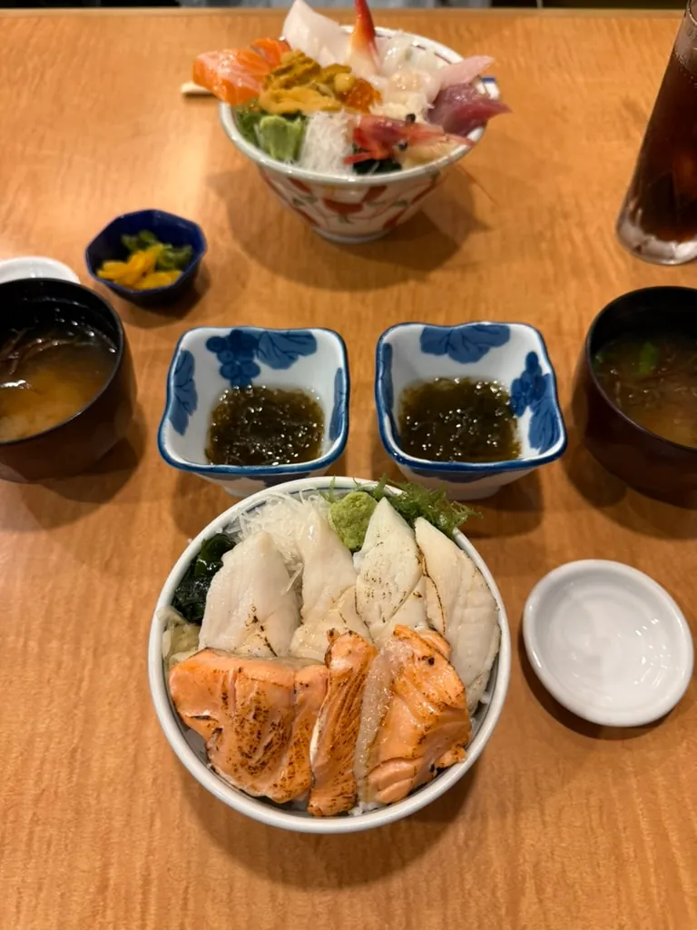
- Sea urchin (uni). Uni is the town's signature product.3 The season runs from early June to the end of August, when uni-don (sea-urchin rice bowls) fill local menus.6
- Home of Soran-bushi. The herring-landing song known nationwide as Soran-bushi is one of the four songs of the Seichō Nishinba Ondo (正調鰊場音頭), which the town preserves.214
- Marine park zone. The sea off Cape Kamui, Cape Shakotan and Biyano Cape is a marine park zone (海域公園地区) of Niseko-Shakotan-Otaru Kaigan Quasi-National Park. Together with the Otaru coast zone, these are the only marine park zones in Hokkaido.15
- Shimamui Coast (島武意海岸). This cove is one of Japan's "100 Best Beaches" (日本の渚百選). It is the only point on the Cape Shakotan cliffs where you can get down to the water's edge.16
- Herring-era heritage. Herring fishing made the town rich until the Taishō era. Old banya bunkhouses, tunnels and roads from that time survive.61
- Misaki no Yu Shakotan (岬の湯しゃこたん). Its open-air bath looks out over both Cape Shakotan and Cape Kamui.17
Sights & activities
Nature & scenery
- Cape Kamui (神威岬), Kōzaki-chō. From the "No Women Allowed Gate" (女人禁制の門), a ridge path of about 770 m leads to the tip in about 20 minutes. From there the horizon curves around 300 degrees.39 Allow about an hour for the round trip from the car park.40 In early summer the path is lined with Ezo day-lilies.39 The car park is free (about 200 spaces).13 Park opening hours (2026), set by the entrance gate on Route 229: April 8:00–17:30; May 8:00–18:00; June 8:00–18:30; July 8:00–18:00; August–October 8:00–17:30; November 8:00–16:30; December–March 10:00–15:00. Last entry is one hour before closing.40 Closure: from 5 October 2026 to early April 2027, the path beyond the gate to the tip is closed while its fences are rebuilt. The viewing area by the car park stays open.41
- Cape Shakotan (積丹岬) and Shimamui Coast (島武意海岸), Irika area. A short tunnel, dug to haul herring up from the cove, opens suddenly onto an overlook of the clear blue water.4216 As of September 2026 the overlook is open. The path down to the beach is closed for repairs until early April 2027.43 The Cape Shakotan nature trail is open except between the Jorōko Rock overlook and the Horomui entrance.43
- Cape Ōgon (黄金岬), Bikuni. A 410 m trail with three entrances leads to the lookout at the tip.44 Takara-jima lies just offshore.23 One entrance is closed during September 2026.43 Park at the Tourism Center, since there is no public parking at the Chatsu-side entrance.45
- Mt. Shakotan (積丹岳, 1,255.3 m). The trail offers alpine flowers such as Japanese wood poppy (シラネアオイ) and views of the Niseko range and Mt. Yōtei. A free rest hut stands near the second station.46 In 2007 an avalanche on the mountain killed four snowmobilers.46
Onsen
- Misaki no Yu Shakotan (岬の湯しゃこたん), Nozuka-chō 212-1. The spring is a sodium chloride–hydrogen carbonate type, 52.6 °C at the source. Facilities include an open-air bath, hot and medium-temperature baths, a bubble bath, a cold plunge and a sauna.17 The tourism association lists admission at ¥1,200 for adults, hours of about 11:00–19:00 and Wednesday closing; check before visiting.17 Since 2022 SHAKOTAN GO has run the onsen. It added a herbal "botanical sauna" and a Taiwanese restaurant, baobao shokubō (baobao食坊), that uses Shakotan ingredients.2447
- Nyasuke no Hoterun (ニャー助のホテルん), Nishikawa-chō. A small hotel on Route 229 with the carbonated spring "Shirara-hime no Yu". Its water comes from a well drilled 900 m deep in 1999.3348 It opened in August 2022 in the building of the former Onsen Ryokan Hokuto, which closed in 2018.48
Museums & heritage
- Lighthouse lens room, Kamui Banya 2F. This is the French-made first-order fixed lens (3.05 m tall) used in Cape Kamui Lighthouse from 1923 to 1960. The town calls it the only surviving first-order fixed lens in Japan. Open late April–late October, 10:30–16:00.49
- Nishin Denshūkan Yamashime Banya (鰊伝習館ヤマシメ番屋), Bikuni-chō Funama 39. The preserved herring house of the Fukui family, with a café. Open May–early October, 9:00–16:00; closed Tuesdays and Wednesdays.50
- Sakuramasu Sanctuary Center (サクラマスサンクチュアリーセンター), Yobetsu-chō 312. It explains the ecology of cherry salmon in the Yobetsu River. Walking paths surround it. Open May–October, 9:00–17:00.51
Outdoor & seasonal activities
- Glass-bottom boat New Shakotan-go (水中展望船ニューしゃこたん号). A 40-minute cruise from Bikuni port past Cape Ōgon, Gome-jima and Takara-jima. Operates late April–October, cancelled in rough seas; listed fare ¥1,900 for adults.52
- Boat tours with fishers. Shakotan Kamui Cruise runs about 50 minutes from Raikishi (来岸) fishing port to Cape Kamui and Kamui Rock. Shakotan Wasen Cruise sails to Makka Cape in about 90 minutes (¥3,500 for adults).53
- Guided tours. Local operators run snorkelling, diving, e-MTB, kayak and SUP tours.53
- Camping. Two free sites need no booking. The Dōei Nozuka Campground (道営野塚野営場) is open early May–end of October. The Bikuni Fishing Port seaside green space (美国漁港海岸緑地広場) is open mid-April–end of October.54
Food experiences
- Uni-don season (June–August) is the main draw. The tourism association's restaurant list includes Misaki, Sugino Uni-zen-ya, Fuji-zushi Honten, Fukuzushi and Shokudō Rinkō (食堂鱗晃) near Cape Shakotan.31
- Shakotan Tourism Center produce market (積丹産直市場), Bikuni-chō Funama 380-6. It sells local products and Unidon goods. Open 10:00–17:00, closed over New Year.12
- Kamui Banya (カムイ番屋), Kōzaki-chō 92. A restaurant and shop at Cape Kamui with up to 120 seats. Open April–October: restaurant 11:20–15:30, shop 10:30–16:00.55
Roadside stations (Michi-no-Eki)
No Michi-no-Eki is located in Shakotan.56 The nearest stations are all on National Route 229:
- Furubira Tarako Museum (道の駅ふるびらたらこミュージアム), Hama-machi 40-4, in neighboring Furubira. It opened in April 2025 as Hokkaido's 129th roadside station. The pink-themed shop and museum celebrate Furubira's cod roe (tarako). The restaurant serves a whole-roe tarako set meal (¥1,600) and tarako salt ramen (¥1,500). Open 9:00–18:00 from April to October and 9:00–17:00 from November to March; closed over New Year.57
- Oskoi! Kamoenai (道の駅オスコイ!かもえない), in neighboring Kamoenai. It was registered in 1996, sells local seafood (live scallops are its best seller), and is open 9:00–17:00, closed 31 December–3 January.58
- Space Apple Yoichi (道の駅スペース・アップルよいち), in Yoichi. It was registered in 1998 and has a space museum honoring Yoichi-born astronaut Mohri Mamoru, plus fruit-based products. In the 2026 season the museum and shop open 9:00–17:00; the museum closes on Mondays and for winter from 1 December 2026 to 16 April 2027.59
Getting there & around
- Rail. No railway reaches Shakotan. The nearest station is JR Yoichi Station on the Hakodate Main Line in Yoichi.6
- Bus. Hokkaido Chuo Bus's Shakotan Line runs from Otaru Station to the Bikuni terminal (about 1 hour 20 minutes).25 Beyond Bikuni, the town's Shako-bus replaced the old Chuo Bus route via Horomui, Irika, Nozuka and Yobetsu to Cape Kamui.6 Some runs operate only on request: book by phone by 17:00 the day before (0135-44-3830). The 2026 summer timetable runs from 1 April to 30 November.25 The Chuo Bus Kamoenai Line from Iwanai ended on 30 September 2024, so Cape Kamui can no longer be reached by bus from the Iwanai side.20
- Car. Route 229 is the only road link to Furubira and Kamoenai. Prefectural Road 913 (Nozuka–Fumi) links settlements inside the town.14 From the Shiribeshi Expressway's Yoichi IC, Misaki no Yu is about 40 km, roughly an hour.48 Cape Kamui is about 70 minutes by car from JR Yoichi Station and 90 minutes from JR Otaru Station.13 Allow roughly 2 hours by car from central Sapporo (unverified estimate).
- Air. The nearest major airport is New Chitose Airport in Chitose.13
Practical tips
- When to go. June–August is peak season for uni and the blue sea; July alone brings well over a third of annual visitors.5 Kamui Banya, the lens room, Yamashime Banya and the glass-bottom boat all operate only within the April–October season.55495052
- Plan around closures. The Cape Kamui gate closes early in winter. From 5 October 2026 to early April 2027 the path to the tip is closed. The Shimamui beach path is shut until early April 2027. Walking paths may close in strong wind.404143
- Bears. Carry a bear bell on all trails. Free bells can be borrowed at Kamui Banya (Cape Kamui), the tourism association (Cape Ōgon) and Shokudō Rinkō (Cape Shakotan).43
- Winter. Expect snow from mid-November to mid-April and strong sea winds on the capes; hold car doors firmly at Cape Kamui.1540 The road from Route 229 to the Cape Kamui car park is cleared daily in winter, but the park paths are snow-covered; wear boots.41
- Services. The only convenience store is the Seicomart in Bikuni, and it has no ATM. Hokkaido Shinkin Bank closed its Bikuni office in November 2025 and moved its ATM into Bikuni Post Office.6 The Shakotan Tourism Association is at 0135-44-3715.1 Campsite toilets are closed November–early April.54
- Drones. The town has rules for flying drones at the tourist sites it manages; check its website first.60
Photos
-
 Aug 2026
More about Shakotan
At a glance
| Field | Details |
|---|---|
| Type | Town (町) |
| Subprefecture | Shiribeshi (後志総合振興局) |
| District | Shakotan District (積丹郡). The town is the district's only municipality.6 |
| Population | 1,831 at the 2020 Census (855 men, 976 women; 883 households).7 The preliminary 2025 Census count is 1,498, down 18.2% in five years. That is the fourth-steepest fall of any Hokkaido municipality.8 The resident register counted 1,587 people (739 men, 848 women) on 31 August 2026.4 |
| Area | 238.13 km² (GSI, 1 April 2026).9 The town spans about 24.1 km east–west and 18.2 km north–south, roughly a quarter of the peninsula.10 The tourism association still quotes an older figure of 238.21 km².3 |
| Density | 7.7 people/km² at the 2020 Census;7 about 6.7/km² on the August 2026 register (calculated from the figures above) |
| Municipal history | The town counts 1706 (Hōei 3) as its founding year.2 Bikuni Village (美国村) was set up as a second-class village in 1902 and became Bikuni Town in 1909. Irika (入舸村) and Yobetsu (余別村) were set up as second-class villages in 1906.6 The three merged on 30 September 1956 to create Shakotan Town, and Bikuni District (美国郡) was abolished.611 |
| Neighboring municipalities | Furubira, Kamoenai6 |
| Symbols | Tree: Sargent's cherry (エゾヤマザクラ). Flower: Ezo day-lily (エゾカンゾウ). Both were adopted in 1987.6 The town emblem (1966) links three gulls for the three merged communities. At its center, Mt. Shakotan, waves and a boat form the character 丹.10 |
| Mascot | Unidon (うにどん), whose name plays on uni-don. The Shakotan Tourism Association launched the character in July 2018.612 The chamber of commerce has an older mascot, Soran Bōya (ソーラン坊や, 1991).6 |
| Official website | https://www.town.shakotan.lg.jp/ |
Name origin
The town's own explanation is that "Shakotan" joins two Ainu words: shak (summer) and kotan (village or home ground). Together they mean "summer place".10 The Hokkaido government's Ainu place-name list gives it as sak-kotan. Nagata Hōsei (永田方正) glossed it as "summer place" (夏場所), because the area was a good fishing ground in summer. Yamada Hidezō (山田秀三) read it as "summer village", noting that Ainu often moved between winter and summer homes. The list rates this etymology at confidence level B.18 The kanji 積丹 ("pile up" + "red") were chosen for their sound and have nothing to do with the Ainu meaning.19 Edo-period records wrote the name 志屋古丹.6
Kamui (神威) comes from the Ainu kamuy, "god". The cape was once also called Okamui-misaki (御冠岬 or オカムイ岬).20
History
- Ainu era and legend. The Ainu revered the Kamui Rock off Cape Kamui as a kamuy. A later legend says that Minamoto no Yoshitsune prayed there for a safe passage.6 Two related Yoshitsune legends tell of Ainu chiefs' daughters. Charenka became Kamui Rock, and Shirara became Jorōko Rock (女郎子岩) at Cape Shakotan.21
- 1691. The Matsumae domain banned Wajin (ethnic Japanese) women from travelling beyond Cape Kamui. Tradition blamed the sea god's anger, but the ban was probably a way to protect the domain's herring rights further north.20 (The Japanese Wikipedia article on Shakotan District dates the ban to 1688.22)
- 1706. The town's official founding year. Trade with the Ainu began around this time, and herring fishing flourished from then on.26
- 1725. Bikuni Shrine (美國神社) was founded, first as an Inari shrine.619
- 1786. The Shakotan trading post (志屋古丹場所) was established.6 In the Edo period the post contractor Iwataya Kinzō (岩田屋金蔵) also cut a road of about 15.7 km from Hizuka to Kodomari. It was the forerunner of today's Route 229 and Prefectural Road 913.22
- 1855. The shogunate lifted the ban on women passing Cape Kamui, and the Shōnai domain guarded the coast.2022
- 1888. Cape Kamui Lighthouse was lit for the first time, the fifth lighthouse in Hokkaido.20
- 1915. The herring boom pushed the population of the area above 11,000.14 As catches collapsed, people began to leave.14
- 1918. Villagers finished the Nenbutsu Tunnel (念仏トンネル) near Cape Kamui. By legend, the two digging teams found each other only by chanting the nenbutsu and ringing bells.20
- 1956. Bikuni, Irika and Yobetsu merged on 30 September to form Shakotan Town.6
- 1962–1963. A coastal national road reached the town in 1962. Until then the town had been a "land-locked island" (陸の孤島), relying on small boats to reach its neighbors.14 In 1963 the coast became part of Niseko-Shakotan-Otaru Kaigan Quasi-National Park.15
- 1966. Shakotan became a sister city of Seaside, Oregon.6
- 1996. The Toyohama Tunnel collapse in neighboring Furubira killed seven Shakotan residents.6 The same year, the last gap in Route 229 between Shakotan and Kamoenai was closed.23
- 2004. Shakotan Peninsula and Cape Kamui became a Hokkaido Heritage site.6 The Furubira, Bikuni-chō and Shakotan fisheries cooperatives merged.14
- 2022. The town-run Misaki no Yu onsen was privatized.24 The French first-order lens used in the lighthouse from 1923 to 1960 came home after about 60 years and went on display at the cape.20
- 2023. Hokkaido Chuo Bus ended its Bikuni–Yobetsu service. The town replaced it with its own community bus, the "Shako-bus" (しゃこバス).25
- 2025. In autumn the local hunting club refused bear-cull call-outs for over a month after a dispute with the assembly's vice-chair. It resumed in November after an apology and a new cull manual.626
Geography & climate
Shakotan occupies the northern tip of the Shakotan Peninsula. Steep ridges run from the peninsula's main peaks, Mt. Yobetsu (余別岳, 1,298 m) and Mt. Shakotan (積丹岳, 1,255.3 m), straight down to the sea.146 Forest covers 83% of the land and flat ground is scarce. Of the forest, 78% is national forest; farmland takes about 6% of the town and housing just 0.4%.14 The coast is 42 km long, with seven fishing ports and ten small settlements along rivers such as the Bikuni, Irika, Shakotan and Yobetsu.14 The state has designated the Shakotan and Yobetsu rivers as protected waters for salmon and cherry salmon.14
The town's coast is part of Niseko-Shakotan-Otaru Kaigan Quasi-National Park (designated 24 July 1963; about 19,009 ha across 11 municipalities). The sea around Cape Kamui, Cape Shakotan and Biyano Cape is a marine park zone, known for rugged sea-floor reefs and stony corals. Together with the Otaru coast zone, these are the only marine park zones in Hokkaido.15 Sea cliffs rise more than 100 m in places, and wave-cut rock pillars dot the coast, among them Kamui Rock and Jorōko Rock.15 Takara-jima (宝島, "Treasure Island") lies off Cape Ōgon. Its name comes from the herring shoals that once gathered around it.23
Climate. The Tsushima Current gives the town a relatively mild climate for Hokkaido. Winters still bring strong northwesterly winds and heavy snow, and the town is a designated special heavy-snow area (特別豪雪地帯).14 At the Bikuni AMeDAS station (1991–2020 normals), the annual mean is 7.7 °C. January averages −4.0 °C and August 20.5 °C. Annual precipitation is 1,899.4 mm, wettest in November–December (about 250 mm a month).27 Records at the station are 35.2 °C (31 August 2023), −17.8 °C (17 February 1978), and 177.0 mm of rain in one day (2 September 2011).28 Level ground in the park area usually stays under snow from mid-November to mid-April.15
Economy & industry
- Fisheries. Coastal fishing with boats under 20 tons is the backbone of the economy. Main catches such as Okhotsk atka mackerel (hokke) and cod swing widely from year to year.14 An older town plan listed Japanese flying squid, sea urchin, northern shrimp (ホッコクアカエビ) and hokke as the top species. Uni and sea cucumber are in demand in Honshu and abroad and are shipped outside Hokkaido.29 The 2023 fisheries census counted 122 fishing businesses and 132 fishers. That is 44.5% fewer fishers than in 2013, and only 12 were under 30.14 The local cooperative, Higashi Shakotan Fisheries Cooperative (東しゃこたん漁協), was formed by a 2004 merger.1429 Kelp-bed loss (磯焼け) is a growing problem, and the town backs kelp restoration and urchin-density control.1429
- Agriculture and forestry. As rice acreage was cut back, farmers moved early to dairy and livestock, helped by a national grassland development project.14 Farm products include potatoes, pumpkins, garlic and Yotsuboshi strawberries.6 Since 2010 a corporate forest-conservation agreement, the "JT Forest Shakotan", has funded forest work tied to river and sea health.14
- Manufacturing and commerce. Two seafood processors employed 8 people in 2024. In 2021, 32 shops and wholesalers had 79 staff and about ¥2.17 billion in sales, as shoppers drift to Yoichi, Otaru and Sapporo.14
- Tourism. Hokkaido's tourism survey counted 1,032,600 visitors in FY2025 (April 2025–March 2026), down 5.9% from 1,096,800 in FY2024. Only 14,000 of them stayed overnight. July alone brought 385,900 visitors, while each winter month saw fewer than 4,000.5 Registered foreign overnight guests fell to 404 (420 guest-nights) in FY2025, from 585 in FY2024.5 The town's plan notes the trend toward day-trip, pass-through tourism and aims for year-round, longer-stay visits.14 In 2020 the tourism association unanimously opposed bids by Kamoenai and Suttsu to host nuclear-waste "literature surveys", fearing harm to the area's image.30
- Population. The 1965 Census counted 6,901 people. By 2020, 46.9% of residents were 65 or older and only 8.1% were under 15.14 One projection in the town plan puts the population at 1,086 by 2040.14 Revitalization efforts include local-revitalization cooperators (地域おこし協力隊) and migration support.14
Local specialties
| Specialty | Category | Details & where to get it |
|---|---|---|
| Nama-uni and uni-don (生うに・うに丼) | Seafood / signature dish | In season early June–late August.6 At Misaki (お食事処 積丹の幸 みさき) the owner catches the uni himself and serves them without preservatives. Sugino Uni-zen-ya (すぎ乃本店 うに膳屋) also serves uni-don and seafood bowls.31 Salted uni (塩水うに) and bottled uni are sold in season by Okawa Shoten.32 |
| Sushi and seafood set meals | Dining | Fuji-zushi Honten (ふじ鮨本店, founded as a diner in 1967) and Fukuzushi (冨久寿し, over 60 years old) serve local catch.31 Bikuni Kankō House (美國観光ハウス) is an auberge that the tourism association describes as Michelin-starred.33 |
| Shakotan nori (積丹海苔) | Seafood | A premium rock laver harvested in February–March.6 |
| Abalone, shrimp, octopus, squid, hokke, anglerfish, yellowtail | Seafood | Listed among the town's specialties. Yellowtail (buri) is landed under the brand name Shihō (鰤宝) and is mostly sold outside the town.6 Smoked split hokke from Kakukichi Shokuhin (かくきち食品) costs from ¥500.32 |
| Shakotan zangi (積丹ザンギ) | Local dish | Fried chicken, the house specialty of the restaurant Jun no Mise (純の店). Frozen 400 g packs are sold at the Tourism Center market.12 |
| Tansui (丹水) | Sake | Local sake made with Shakotan water. It comes as dry junmai genshu and sweet junmai ginjō genshu (300 ml, ¥1,550) and is sold only in town.32 Kamuizuru (神威鶴) is a junmai sake.6 |
| Craft gin 火の帆 | Spirits | Made by the Shakotan Spirit distillery (積丹スピリット). Japanese Wikipedia romanizes the brand as "HONOHO".6 |
| Kamui no Shihō (神威の紫宝) | Processed food | Additive-free black garlic made from Hokkaido-native garlic and spring water from Mt. Shakotan. A black-garlic vinegar is also sold.12 |
| Shakotan Blue soft-serve and ramune | Sweets | Blue soft-serve6 and "Shakotan Blue Ramune" (a soda in the colour of the sea)12 |
| Shakotan manjū (積丹まんじゅう) | Sweets | Bite-size brown-sugar buns filled with smooth bean paste, 8 for ¥700, sold at the Tourism Center.32 |
| Glass fishing floats (浮き玉) | Craft | Glass floats used in cod and pollock fishing until the 1970s, cleaned and re-netted for sale12 |
| Furusato nōzei gifts | Hometown tax | Salted raw uni and purple sea urchin (ムラサキウニ), and ikura in soy sauce. Farm gifts include Kitaakari potatoes and Kuriyutaka pumpkins; the pumpkins are grown with 100% organic fertilizer and compost.34 Donors can direct money to five themes, including coastal clean-ups at Cape Kamui and Shimamui and release of uni and herring fry.35 |
Culture & festivals
| Event | When | Highlights |
|---|---|---|
| Shakotan Soran Mikaku Matsuri (積丹ソーラン味覚祭り) | June; traditionally the last Sunday636 | Marks the opening of uni season. A "beach-price morning market" sells fresh uni and fish. The fish hotpot (浜鍋) includes shrimp and scallops. On stage: the herring-work songs and YOSAKOI Soran dancing.36 The tourism association's Japanese events page no longer shows this festival, and its English page was last updated in 2021, so check before planning a trip (2026 staging unverified).37 |
| Bikuni Shrine Festival, the "fire festival" (美國神社例大祭) | Eve on 4 July; main days 5–6 July | A sea procession under big-catch flags and a parade of mikoshi and floats. At night, a tengu and the mikoshi pass through fire (天狗の火渡り/火くぐり)376 |
| Kamui Shrine Festival (神威神社例祭) | 17 July | Annual festival of Kamui Shrine38 |
| Matsuri no Oto (祭の音) | August | Listed among current annual events; details not confirmed6 |
| Shakotan Kei-tora Ichi (しゃこたん軽トラ市) | September | Market sold from the backs of light trucks6 |
| Shakotan Autumn Festival (積丹オータムフェスティバル) | October | Autumn food event6 |
| Town Culture Festival (積丹町総合文化祭) | November | Performances and exhibitions6 |
- Soran-bushi and the herring songs. The Seichō Nishinba Ondo has four parts. The funakogi ondo was sung while rowing to the nets and the ami-okoshi ondo while hauling them. The okiage ondo, the song now known as Soran-bushi, was sung while scooping herring ashore. The kotataki ondo went with beating herring roe off the nets.26 The Shakotan Nishinba Ondo Preservation Society keeps the songs alive. They became a town intangible folk cultural property in February 1988, but the society is ageing and short of successors.14
- Kamui Kagura (神威神楽). A shrine dance handed down in the Yobetsu district, which faces the same succession problems.14
- Shrines. Kamui Shrine (神威神社) is the chief guardian shrine (総鎮守) of Shakotan District.6 It began as a Matsumae-era shrine at Kōzaki (神岬). It moved to Raikishi (来岸) in 1866 and to its present site in 1870.38 Bikuni Shrine dates from 1725.6
- Monuments. A Soran-bushi monument faces Takara-jima.23 Singer Matsuyama Chiharu's "Roman no Hi" (2015), on the Cape Ōgon trail, recalls his great-grandfather, who died in Bikuni.6
Ainu heritage
Little Ainu history specific to Shakotan is documented in accessible sources. The clearest traces are place names. Shakotan itself comes from sak-kotan, and Kamui from kamuy.1820 The Ainu revered Kamui Rock as a kamuy long before Japanese shrines were built at the cape.6 The Edo-period Shakotan and Bikuni trading posts show that the Matsumae domain traded with Ainu here.2211 The romantic legends of Charenka and Shirara, told at Cape Kamui and Cape Shakotan, are built around Minamoto no Yoshitsune, a figure from Japanese (Wajin) legend. The sources consulted do not present them as Ainu oral tradition.2120 No Ainu cultural facility in the town turned up during research.
Sister & friendship cities
Notable people
Sources
Numbers in the text link to these sources. Figures as of 23 September 2026
- 積丹半島と神威岬 — 北海道遺産協議会 JA accessed 2026-09-23
- ソーラン節のふるさと — 積丹町役場 JA accessed 2026-09-23
- 積丹の概要 — 積丹観光協会 JA accessed 2026-09-23
- 住基ネットにおける人口【参考値】(令和8年8月末日現在) — 北海道総合政策部地域行政局市町村課 JA accessed 2026-09-23
- 北海道観光入込客数調査報告書(令和7年度 資料編) — 北海道経済部観光局 JA accessed 2026-09-23
- 積丹町 — Wikipedia JA accessed 2026-09-23
- 令和2年国勢調査結果 統計表 第1表 男女別人口、面積、人口密度及び世帯数(XLS) — 北海道総合政策部計画局統計課 JA accessed 2026-09-23
- 令和7年国勢調査速報 北海道の人口・世帯数 — 北海道総合政策部計画局統計課 JA accessed 2026-09-23
- 令和8年全国都道府県市区町村別面積調(4月1日時点) — 国土地理院 JA accessed 2026-09-23
- 積丹町の概要 — 積丹町役場 JA accessed 2026-09-23
- 美国郡 — Wikipedia JA accessed 2026-09-23
- 積丹産直市場 — 積丹観光協会 JA accessed 2026-09-23
- Cape Kamui — HOKKAIDO LOVE! (Hokkaido Tourism Organization) EN accessed 2026-09-23
- 積丹町過疎地域持続的発展計画(令和8年度~令和12年度、令和8年3月) — 積丹町 JA accessed 2026-09-23
- ニセコ積丹小樽海岸国定公園 — 北海道環境生活部自然環境局 JA accessed 2026-09-23
- 積丹岬・島武意海岸(しまむいかいがん) — 積丹観光協会 JA accessed 2026-09-23
- 岬の湯しゃこたん(宿泊有) — 積丹観光協会 JA accessed 2026-09-23
- アイヌ語地名リスト シベ~セツ P61-70(Internet Archive copy) — 北海道環境生活部アイヌ政策推進室 JA accessed 2026-09-23
- Shakotan, Hokkaido — Wikipedia EN accessed 2026-09-23
- 神威岬 — Wikipedia JA accessed 2026-09-23
- 積丹の伝説 — 積丹観光協会 JA accessed 2026-09-23
- 積丹郡 — Wikipedia JA accessed 2026-09-23
- 積丹半島 — Wikipedia JA accessed 2026-09-23
- 産業交流雇用対策推進施設(岬の湯しゃこたん)の民営化について — 積丹町役場 JA accessed 2026-09-23
- 『積丹町生活交通バス』の運行について — 積丹町役場 JA accessed 2026-09-23
- ハンター出動"拒否"問題が終息か…積丹町は新たなルールを定め、猟友会は活動再開 — TBS NEWS DIG JA accessed 2026-09-23
- 美国(後志地方) 平年値(年・月ごとの値) — 気象庁 JA accessed 2026-09-23
- 観測史上1~10位の値(美国) — 気象庁 JA accessed 2026-09-23
- 積丹地域マリンビジョン計画(改訂版) — 積丹町 JA accessed 2026-09-23
- 「核ごみ処分場」問題について(令和2年10月6日) — 一般社団法人積丹観光協会 JA accessed 2026-09-23
- お食事処・飲食店 — 積丹観光協会 JA accessed 2026-09-23
- おみやげ・商店 — 積丹観光協会 JA accessed 2026-09-23
- 宿泊施設 — 積丹観光協会 JA accessed 2026-09-23
- 北海道積丹町のふるさと納税 お礼の品ランキング — ふるさとチョイス JA accessed 2026-09-23
- ふるさと納税にご協力ください — 積丹町役場 JA accessed 2026-09-23
- Events — Shakotan Tourism Association EN accessed 2026-09-23
- イベント — 積丹観光協会 JA accessed 2026-09-23
- 神威神社 — Wikipedia JA accessed 2026-09-23
- 神威岬(かむいみさき)・神威岩(かむいいわ) — 積丹観光協会 JA accessed 2026-09-23
- 神威岬自然公園の開園・最終入園時間について(2026年9月7日更新) — 積丹町役場 JA accessed 2026-09-23
- 神威岬遊歩道「工事に伴う 一部通行止め」のお知らせ(2026年10月5日~2027年4月上旬) — 積丹町役場 JA accessed 2026-09-23
- 島武意海岸 — Wikipedia JA accessed 2026-09-23
- 「自然遊歩道」の開放状況について(2026.9.7更新) — 積丹町役場 JA accessed 2026-09-23
- 黄金岬(おうごんみさき) — 積丹観光協会 JA accessed 2026-09-23
- 本日9月23日(水)の観光情報をお知らせします。 — 積丹観光協会 JA accessed 2026-09-23
- 積丹岳 — Wikipedia JA accessed 2026-09-23
- 岬の湯しゃこたん|株式会社SHAKOTAN GO — 株式会社SHAKOTAN GO JA accessed 2026-09-23
- 積丹温泉 — Wikipedia JA accessed 2026-09-23
- 神威岬灯台「第一等不動レンズ」里帰り記念展示室について — 積丹町役場 JA accessed 2026-09-23
- 鰊伝習館 ヤマシメ番屋 — 積丹観光協会 JA accessed 2026-09-23
- サクラマスサンクチュアリーセンター — 積丹観光協会 JA accessed 2026-09-23
- 積丹水中展望船 ニューしゃこたん号 — 積丹観光協会 JA accessed 2026-09-23
- 施設情報(アウトドア・レジャー施設) — 積丹観光協会 JA accessed 2026-09-23
- 道営野塚野営場・美国漁港海岸緑地広場の利用について — 積丹町役場 JA accessed 2026-09-23
- しゃこたん土産と喰処 カムイ番屋 — カムイ番屋 JA accessed 2026-09-23
- 道の駅一覧 — 北海道の道の駅(北の道の駅) JA accessed 2026-09-23
- ふるびらたらこミュージアム — 北海道の道の駅(北の道の駅) JA accessed 2026-09-23
- オスコイ!かもえない — 北海道の道の駅(北の道の駅) JA accessed 2026-09-23
- スペース・アップルよいち — 北海道の道の駅(北の道の駅) JA accessed 2026-09-23
- 観光 — 積丹町役場 JA accessed 2026-09-23